|
Ferry van Eeuwen
|

|
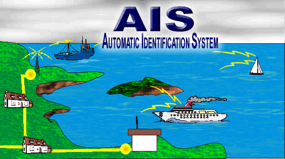
Shipplotter Automatic Identification System (AIS) In recent years Europe, particularly along the Atlantic coastline, has seen a number of disastrous accidents involving oil tankers (Torrey Canyon, Amoco Cadiz, Tanio, Braer, Aegean Sea, Erika and Prestige). These have had catastrophic economic and environmental consequences. Because of the volume of traffic and the resultant high risk to shipping in European waters, national maritime agencies have introduced ship routing systems, approved by the International Maritime Organization (IMO). Improved ship routing has helped to limit the risk of collision. However, the existing systems have limited geographical scope and concentrate on the main zones of traffic convergence without properly covering events that could occur outside the range of radar or shore-based automatic identification system (AIS) centers. To meet this demand the Long Range Identification and Tracking (LRIT) system is under development. Further on more information about the LRIT system is provided.
As specified by IMO, AIS is a broadcast system operating in the VHF maritime radio band (161.975 Mhz and 1621.025 Mhz) and capable of sending and receiving ship information such as identity, position, course, speed, ship particulars, and cargo information to and from other ships and shore. It can handle more 2,000 reports per minute and updates information as often as every two seconds. A mandatory implementation schedule depends on the type of the vessel (passenger ships, tankers, 300 gross tonnage vessels, and so forth). The final installations have occurred at the end of 2004. In December 2002, the IMO introduced the International Ship and Port Facility (ISPS) code, as an amendment to the International Convention for the Safety of Life at Sea (SOLAS) of 1974. IMO also recommended that measures should be introduced at the earliest opportunity to provide long-range identification and tracking of SOLAS vessels. The code, which becomes effective from July 1, 2004, aims to provide defined procedures for maritime security at the ship/port facility interface. Long Range Identification and Tracking of incoming vessel traffic and cargo is therefore an important factor in the assessment of risk and the definition of appropriate security procedures.
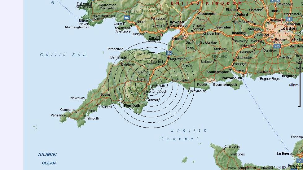
If This is a live plot of ships sailing in the English Channel. The date and time stamp are in the lower right corner of the picture. The picture is refreshed every 60 secons. Notice the shipping routes being used and also the cross traffic from France to England and v.v. To get a larger picture please click on the above picture.
For an actual AIS picture of Hook of Holland click on the picture of the thirsty little bird above
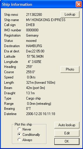
Right clicking on a ship on the map produces a pop-up screen with quite a lot of the ship's essentials. When the Photo button is clicked a Google search is started for a picture of the ship.
Some information on the future Long Range Identification and Tracking (LRIT) system that will be implemented already on and after 31/12/2008. As specified by IMO, AIS is a broadcast system operating in the VHF maritime radio band and capable of sending and receiving ship information such as identity, position, course, speed, ship particulars, and cargo information to and from other ships and shore. It can handle more 2,000 reports per minute and updates information as often as every two seconds. A mandatory implementation schedule depends on the type of the vessel (passenger ships, tankers, 300 gross tonnage vessels, and so forth). The final installations will occur before end of 2004. Following the terrorist events on September 11, 2001, fears were expressed that ships could be used to transport noxious devices or substances, or that ships could be used themselves as floating bombs. One obvious solution to the problem is to monitor the progress of vessels at sea and identify those that might pose a threat. Long Range Identification and Tracking (LRIT) can do this. Under LRIT, every vessel would regularly transmit, via satellite, its unique identity (e.g. an Inmarsat C ID), its position (Latitude/Longitude) and the date and time of the position.
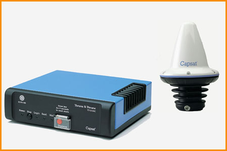
An example of an Inmarsat C (data only) terminal for shipboard use. Proposals for a long-range identification and tracking (LRIT) solution for ships - which would use existing Inmarsat technology and aims to enhance maritime security - have made significant progress at the 80th session in May, 2005 of the International Maritime Organization (IMO) Maritime Safety Committee (MSC 80). The IMO, at the 81st session of the Maritime Safety Committee (MSC 81), 10-19 May 2006, agreed a draft SOLAS Amendment on LRIT, which requires that ships shall be fitted with LRIT equipment to transmit automatically the information (ship's ID, position, date/time of position) as follows: * ships constructed on or after 31/12/2008; * ships constructed before 31/12/2008 and certified for operations in sea areas A1, A2 and A3 not later than the 1st survey of the radio installation after 31 December 2008; and * ships constructed before 31/12/2008 and certified for operations in sea areas A1, A2, A3 and A4 not later than the 1st survey of the radio installation after 1 July 2009. However, these ships shall comply with the provision of paragraph 2 above whilst they operate within sea areas A1, A2 and A3. The LRIT equipment on board ships must interface directly to the shipborne Global Navigation Satellite System (GNSS) equipment, or have an internal positioning capability. LRIT requires that the frequency of transmission can be controlled remotely, without intervention on board; allowing for an increase in LRIT transmission frequency as security levels change, in order to perhaps observe a particular vessel or vessels more closely. At security Level 1 (the lowest level), all passenger vessels on international voyages, all cargo vessels including high-speed craft over 300 gross tonnes and mobile offshore drilling units must transmit the required LRIT data every six (6) hours. If security levels change to 2 or 3, or if a particular vessel or vessels is/are of more interest, LRIT transmissions and monitoring can be increased remotely as required, up one LRIT report every 15 minutes. The Inmarsat technology to make this work efficiently already exists. Indeed, LRIT data can be provided now, using Inmarsat C, mini-C or D+. The Inmarsat terminal on the vessel has a built-in global positioning system (GPS) receiver, which provides the vessel's position. The Inmarsat terminal also has a built-in unique identity, or ID. Remote control is already possible today with Inmarsat C, mini-C and D+ MSC 81 agreed to set up an ad hoc Working Group on the Engineering Aspects of LRIT. This group will meet three times between MSC 81 and MSC 82 (29 November-08 December 2006), with the first meeting 21-23 June in Vancouver. This group will develop, inter alia, the terrestrial infrastructure requirements for LRIT and will report back to MSC 82. |