|
|
|
|
|
Ferry van Eeuwen
|

|
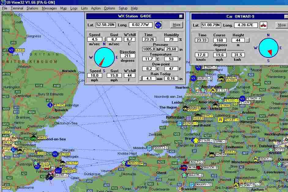
APRS Automatic Position Reporting System of kort APRS is een vinding van de Amerikaan Bob Bruninga, WB4APR. Het is een systeem dat door radiozendamateurs gebruikt wordt om positiegegevens, weerrapporten en in beperkte mate ook tekst over te brengen of uit te wisselen. Het is gebaseerd op het Packet Radio ptrocol AX.25A, een 'mobiele'variant van het AX.25 protocol dat op landlijnen (in NL toegepast in Datanet 1 en 2 van KPN Telecom) wordt gebruikt. Er zijn verschillende software-pakketten beschikbaar, waarvan die van Roger Barker/G4IDE vooral in Europa veel toegepast wordt. In mobiele toepassingen is de zend/ontvanger via de software gekoppeld aan een GPS-ontvanger. Om de paar minuten wordt een positiemelding doorgegeven aan het radionetwerk. Deze geeft de gegevens in een soort estafette aan elkaar door. In de meeste gevallen gaan deze gegevens ook nog via een repeater of herhaal station, waarvan sommige gekoppeld zijn aan het internet, de wijde wereld in. Radioamateurs kunnen de pakketjes met informatie uit de lucht plukken en zichtbaar maken op een landkaart. Door een koppeling met het internet tot stand te brengen kan tevens de APRS-gegevens elders in de wereld bekeken worden. Zie onderstaande plaatjes die ik onlangs maakte. Het is mogelijk om een bepaald mobiel station te volgen of te 'tracken'. De snelheid en richting van het voertuig kan zo van moment tot moment gevolgd worden. Er is een optie waarmee peilingen van een station gedaan kan worden. Al met al hebben radioamateurs een professioneel zogenaamd AVLS (Automatic Vehicle Location System) voor heel weinig geld tot hun beschikking. Daar moeten bedrijven en instanties heel wat Euro's voor neertellen! Voor verdere informatie verwijs ik naar de volgende url's: http://web.usna.navy.mil/~bruninga/index.htm http://www.ui-view.com/ Roger Barker/G4IDE wrote a very nice of APRS software. The programa is called UI-View and is freeware. I use the shareware version UI-View32 myself. The latest version is V1.66 and is shown next. Furthermore the web site has lots of links to sites with all kinds of add-ons.
This APRS picture was taken on Saturday February 8, 2002 at 23:26 local time. A little bit to the East of Rotterdam you can see my radio amateur call sign PA0EEU. Double clicking on any icon will reveal information. I have done that on the icons of G4IDE, Roger Barker in the UK, the author of this very sophisticated program and of ON1MAR near Antwerp, who has the equipment in his car. Roger has a weather station connected to his transmitter. See the relevant box as an example. Apart from his exact position all weather details are shown. The exact position of ON1MAR's car and the speed and direction can be read from the other box. In his case a GPS (Global Position System) unit is connected to the transmitter in his car. The car's position is updated every minute or so. In this case the program thus serves as a AVLS (Automatic Vehicle Location System)! Via the internet I can also see the actual live weather in large parts of the world, as well as the position and movement of cars out there. Quite neat, isn't it?
|